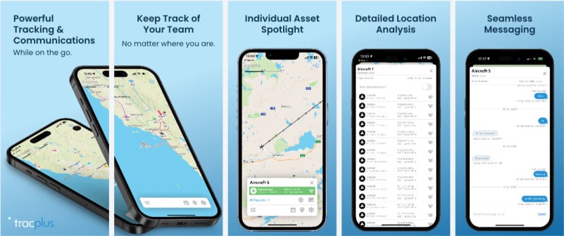
The new TracPlus iOS app leverages the latest in Apple technologies and has been completely rewritten from the ground up, ensuring seamless performance and enhanced functionality.
Listening to valuable feedback from customers, both recent and past, TracPlus has incorporated several user-centric changes into the app's user interface (UI). The refreshed layout reflects the company's dedication to optimizing the application for users in the field.
Key changes introduced in the TracPlus iOS app include:
1. Persistent data: The app now supports offline functionality, enabling the storage of report data on the device. This enhancement eliminates the need to fetch data over the wire upon application restart, allowing users to view last known locations even without an internet connection.
2. Messaging conversation: Messages and replies are now displayed in a conversation format, enabling users to view conversations in context. The app's notification system also directs users to the messaging view when the application is running in the background.
3. Improved Map Interaction: Users can now view report data directly from the context of the assets on the map, eliminating the need to switch between reports lists and map views.
4. Optimized User Experience: Fixed UI elements have been minimized, optimizing the screen real estate for map-related activities and providing a more immersive experience.
5. Enhanced Icons: The app features improved asset icons, highlighting major aircraft makes and models. These improvements have already been back-ported to TracPlus Cloud and will be implemented in the Android application as well.
6. Trail Modes: The app introduces multiple trail modes, offering users more options to view or constrain information on the map.
7. Searchable: The assets list is now searchable and filterable, simplifying the identification of specific assets. Reports can also be filtered to display only non-standard events, making it easier to identify takeoff, landing, and drop events.
8. Transport State: Asset and Report contexts now provide immediate visibility into GSM or Satellite transmission information, available in both lists and on the map.
9. Network State: The app now visually indicates the device network status. Additionally, it prevents message sending while offline, with plans to implement a queue system for dispatching messages once network coverage is restored.
10. Dark Mode Support: TracPlus iOS app now seamlessly supports the device's mode setting, offering a more personalized and comfortable user experience.
11. Dedicated iPad Support: The app now features dedicated support for iPad, providing an optimized interface for users leveraging the larger screen.
12. Expanded Login Options: Users can now log in to the TracPlus app using Microsoft SSO or TracPlus email credentials, offering increased convenience and flexibility.
TracPlus is excited about the release of its new iOS app and is committed to delivering further updates and enhancements for customers.
To learn more about TracPlus, visit www.tracplus.com and download the new 'TracPlus for iOS' app on the App Store.
About TracPlus
TracPlus specializes in developing leading telemetry and data solutions that make wildfire-fighting organizations safer and more efficient. TracPlus is the only commercial provider to deliver a whole-of-country solution for integrated aircraft tracking in the wildfire management space. We do this by tying multiple data streams and asset types into a single view of the truth for mission-critical operations and deliver situational awareness to operators, irrespective of who owns the asset, what the asset is, who provides the tracking, or what the platform or signal type is — be it IP, IoT, cellular or satellite. Our powerful, cloud-based platform enables our customers to track, manage, monitor, and message their personnel and resources, including land, maritime, and aviation assets, to keep crews safe, conserve resources, and maximize coordinated efforts. As the trusted provider of the mission-critical tracking and communications platform for first responders, government agencies, militaries, and other critical operators around the world, TracPlus has been present at virtually every major disaster response globally in the past five years.
Company History
TracPlus has its roots in search and rescue after a boating triple-fatality in 2003 off the coast of New Zealand's South Island. The vessel had a traditional 121-style rescue beacon which provided a basic locational signal but due to the requirement of multiple satellite passes to pinpoint the rescue location it meant that four possible locations for the party were identified on different sides of the country. It wasn't until almost three hours after the initial incident occurred that the rescue team were able to find the vessel by which time three of the six occupants had succumbed to the treacherous conditions.
Following this incident, the pilot of the rescue helicopter and a local technology enthusiast got together to come up with a better way to find people in distress; by actively tracking them all the time, not just when they need help. In late 2005, a small satellite-based tracking terminal was fitted to a helicopter and 18 months later, TracPlus Global was born. Since then we've earned the trust of customers in over 40 countries, have supported over 9,500,000 operational hours of firefighting, search and rescue, EMS transfers, and more.
For more information, contact TracPlus at marketing@tracplus.com
